You know the ocean makes Boothbay magical, but when you buy on the water, the tide can change more than your view. The difference between a tidal shoreline and a deep-water shoreline can shape your daily routine, boating access, permits, insurance, and long-term value. If you want clarity before you commit, you are in the right place. In this guide, you will learn the practical differences, how to evaluate a property, and what to plan for in Boothbay’s harbors and coves. Let’s dive in.
Tidal vs. deep-water, in plain English
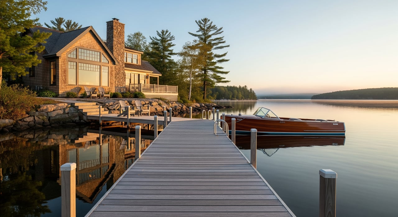
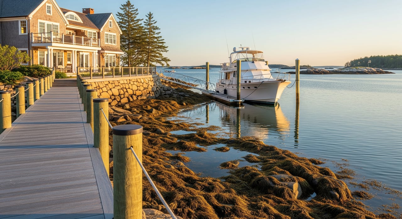
Tidal waterfront is shoreline where water level and what you can use changes with the tide. At low tide you may see mudflats or ledge, and your float or mooring could be too shallow to use until the water returns. Your boat access often depends on timing.
Deep-water, in local terms, means there is enough depth at low tide for safe, year-round navigation and mooring of larger vessels. There is no single depth that defines it. What counts as deep water depends on your boat’s draft, nearby channels, and local sea floor contours.
Here is the key idea: these are market terms, not legal definitions. You should confirm actual depths and usability for each property, especially at mean lower low water.
Boothbay waterfront realities
Geography and tides
Boothbay and Boothbay Harbor feature classic rocky coastline, islands, ledges, and protected coves. The tide matters here. You should review tide predictions for the Boothbay Harbor tide station and study local nautical charts that show soundings at mean lower low water and any hazards.
Navigation and services
The region offers marinas, moorings, and boatyards. Local harbor offices and marinas can share slip availability, waiting lists, and dredging history. If you rely on consistent boating, a protected basin with dependable access is a real advantage.
Access and usability fundamentals
If you plan to boat, swim, or use a float, start with how and when you can access the water.
- Confirm low-tide depth alongside any dock, float, or mooring.
- Check the route to open water for shoaling, ledges, or narrow channels.
- Ask about dredging history near the property or along the channel.
- Match your vessel’s draft to the measured depths at low tide.
On tidal shorelines, you may have a lovely intertidal landscape but limited windows for boating. Deep-water properties typically allow easier access at all tide stages and can support larger boats.
Ownership and boundary basics
Your rights at the shore depend on lines you cannot see without a survey. Two important markers are Mean High Water and Mean Low Water. Deeds may differ in how they describe waterfront boundaries and foreshore ownership.
- Verify the deed, any easements, and whether riparian or littoral rights are included.
- Order a coastal survey tied to tidal datums to locate MHW and MLW on the ground.
- Confirm whether the foreshore is private, subject to public trust, or governed by town policies.
Clear boundaries and rights reduce friction when you permit a dock, assign a mooring, or sell.
Permits and who to call
Shoreline projects in Boothbay usually touch more than one rulebook. Early conversations save time.
Town rules and shoreland zoning
The Town of Boothbay and Boothbay Harbor administer shoreland zoning and building permits. Piers, ramps, floats, bulkheads, and seawalls typically require local approvals that govern location, size, and materials.
Maine DEP and NRPA
The Maine Department of Environmental Protection oversees shoreland zoning standards and the Natural Resources Protection Act for activities affecting tidal wetlands and other resources. Dock work and shoreline alterations often trigger DEP review.
U.S. Army Corps of Engineers
Work below the mean high water line in navigable waters, including dredging or fill, may require federal permits. Smaller projects sometimes qualify for a Nationwide Permit, but you must verify eligibility.
Moorings and slips
Moorings are managed with harbormaster oversight and permits. Assignments often follow waiting lists and may renew annually. Some properties have private docks, while others rely on shared facilities or town mooring fields.
Infrastructure choices and upkeep
Waterfront access can be built in many ways, and each option has trade-offs.
- Floating docks: Flexible with tide, often paired with a ramp and seasonal removal. Exposure to ice and storms can limit placement.
- Fixed piles and piers: Stable walking surface, typically more complex to permit and install.
- Ramp and float systems: Common solution for variable tides, with seasonal management.
- Shoreline stabilization: Stone revetment or bulkheads may be regulated and must match site conditions.
Costs vary widely based on design, materials, exposure, water depth, and whether you need pile driving or specialty equipment. In Boothbay, local marine contractors and marinas provide the most accurate pricing and maintenance expectations.
Maintenance is part of the plan. Tidal exposure, ice action, wood rot, and marine borers affect lifespan. Seasonal removal or securing of floats is common. Expect recurring repairs and eventual replacement.
Risk, insurance, and resilience
If a property lies in a FEMA Special Flood Hazard Area, your lender may require flood insurance. You can check the relevant Flood Insurance Rate Map panels and obtain an elevation certificate to confirm the home’s flood risk and rating.
Insurance costs reflect more than flood lines. Wind, storm surge, and wave exposure matter, and some insurers price different shorelines differently based on exposure. Risk Rating 2.0 and private-market options can change premiums, so it pays to consult a local coastal insurance agent early.
Plan for the future as well. Rocky segments of coast can be stable, but soft shorelines and developed edges may change over time. Review sea level rise tools and local shoreline data to understand long-term trends. These factors can influence resale and the feasibility of shoreline protection.
Utilities, septic, and site constraints
Shoreland zoning sets minimum setbacks for septic systems. Tight lots can limit options or require advanced designs. Confirm access to water, sewer, and electric. Some islands and remote shorelines rely on private wells, on-site wastewater, or backup power. Wastewater upgrades near tidal water can trigger additional review.
Winter and year-round realities
In severe winters, shallow coves may freeze or become hazardous, which affects boat access and maintenance. Sheltered deep-water moorings and protected harbors are more likely to remain usable. Boothbay marinas and boatyards offer haul-out and winter storage, so confirm availability and policies before you need them.
Market and value trade-offs in Boothbay
Deep-water frontage often commands a premium because it supports reliable boating and larger vessels. Tidal frontage appeals to buyers who love tide pools, quiet coves, and dramatic intertidal views. Privacy, setting, and views can offset reduced boating access for some buyers.
Value is never one-size-fits-all. Exposure to storms, ease of reaching marinas and services, quality of existing docks, and permitting constraints all matter. Seasonal rental demand can favor properties with better boating access. The right match depends on how you will use the shoreline.
Buyer due diligence checklist
Gather documents and line up experts before you write an offer. Here is a concise list you can use:
- Deed, recorded easements, and any covenants that affect dock or mooring rights.
- Property survey showing elevations and the relationship to MHW and MLW.
- Existing permits and permit history for docks, dredging, seawalls, or shoreline work.
- Nautical chart excerpts and tide station data for Boothbay Harbor.
- FEMA flood map panels and any existing elevation certificate.
- Harbormaster records for mooring rules, assignments, and dredging history.
- Town shoreland zoning and building permit requirements.
- Environmental assessments if tidal marsh or wetlands are present.
Helpful professionals to engage early:
- Coastal or marine surveyor to verify water depths at low tide and confirm mean water lines.
- Licensed land surveyor for boundary and elevation work tied to tidal datums.
- Maritime or naval architect for larger dock or mooring projects.
- Local marine contractor and harbormaster to validate access and costs.
- Coastal or real estate attorney for deed, easement, and title issues.
- Local flood insurance agent to scope premiums and elevation needs.
Smart prep for sellers
You can speed up due diligence and protect your price by preparing a clean file.
- Compile permits, surveys, dock plans, and any approvals or renewals.
- Photograph the shoreline at both low tide and high tide.
- Document shoreline protection, repairs, or changes over time.
- Clarify mooring or slip rights and whether they are transferable.
- Disclose known issues such as easements, waiting lists, or any violations.
Buyers will ask detailed questions. Clear answers build trust and keep your timeline on track.
How HARVEY guides your decision
You deserve a straightforward, high-touch process for a complex purchase. HARVEY Real Estate Group pairs local insight with a consultative approach so you can choose confidently.
- Precision scouting: We help you read tide data, nautical charts, and surveys to confirm low-tide usability.
- Permit strategy: We coordinate early conversations with the town, Maine DEP, USACE, and the harbormaster so you understand feasibility and timing.
- Value clarity: We weigh exposure, access, infrastructure quality, and regulatory constraints to price or bid with intent.
- White-glove execution: We line up surveyors, marine contractors, insurance advisors, and marinas, then manage the details through closing.
Whether you want deep-water access for a yacht or a quiet tidal cove for tide pools and privacy, you will move forward with clear facts and a plan.
Ready to talk through a specific shoreline or a potential project in Boothbay? Connect with Colin Harvey for discreet, concierge guidance tailored to your goals.
FAQs
What does “deep-water” mean in Boothbay real estate?
- In local terms, deep-water means there is enough depth at low tide for safe, year-round navigation and mooring of larger vessels, but the exact depth depends on your boat and local contours.
How do I confirm low-tide depth for a Boothbay property?
- Check nautical charts and tide data for Boothbay Harbor, hire a coastal or marine surveyor to measure depths at mean lower low water, and ask about shoaling or dredging history nearby.
Do I need permits to build a dock in Boothbay?
- Yes. Expect local shoreland zoning and building permits, state review by Maine DEP under NRPA, and potentially a U.S. Army Corps permit for work below mean high water.
How are moorings assigned in Boothbay Harbor?
- Moorings are managed by the harbormaster under permit, often with waiting lists and annual renewals. Some properties have private dock rights while others rely on mooring fields or shared facilities.
What insurance factors matter for coastal homes in Boothbay?
- Lender requirements, FEMA flood zones, elevation certificates, wind and surge exposure, and the newer Risk Rating 2.0 all influence premiums. A local coastal insurance agent can estimate costs.
Does tidal vs. deep-water frontage affect resale value?
- Often yes. Deep-water tends to command a premium for dependable boating. Tidal frontage can attract buyers who value scenery and privacy. Location, exposure, and infrastructure also drive value.
What should sellers prepare before listing a waterfront home?
- Gather surveys, permits, dock documents, tide-stage photos, and disclosure of mooring rights or limitations, plus any shoreline work history or outstanding issues.